


Industry-Rice Earth Science Symposia (IRESS)
PETROLEUM GEOSCIENCE LECTURE SERIES
April 14, 2014
4:00-5:00 PM
Room 100 Keith-Wiess Geology Laboratories

Paul M. (Mitch) Harris
Chevron Fellow and Senior Research Consultant
Chevron Energy Technology Company
Adjunct Faculty - Department of Earth Science, Rice University
Coffee at 3:30pm in the second floor library and reception
on the patio fillowing the lecture (5:00-6:00pm)
Great Bahama Bank: Mapping Water‐Depth Variation and Depositional Facies on a "Flat‐Topped" Isolated Carbonate Platform
Abstract: Great Bahama Bank (GBB) has long served as a frequently visited and well‐studied example of a flat‐topped, isolated carbonate platform. As defined by a 30m water depth contour, GBB extends over 103,000 sq. km. The maximum variation in depth‐elevation over this vast platform extends from the 30 m contour to the highest Pleistocene eolianite ridge of 63m on Cat Island. As islands occupy only 8% (or 8,000 sq. km) of GBB, we focus here on the bathymetric variation. We have used Landsat ETM+ imagery (a mosaic of 13 images) and an extensive set of water depth measurements (5,700 digitized soundings) to critically evaluate the magnitude and patterns of bathymetry across GBB. GBB also stands behind many of the models used to illustrate depositional facies variation on carbonate platforms, models which have long served as subsurface analogs at a variety of scales. We also used the Landsat TM imagery, the bathymetric digital elevation model, and seafloor sample data compiled into ArcGIS and analyzed with eCognition to develop a depositional facies map that is more robust than previous versions. Of particular importance is the detailed and generalized distributions of muddier lithologies and grainier lithologies shown by our mapping relative to that of previous maps. GBB is essentially a very grainy platform with muddier accumulations only in the lee of substantial island barriers; in this regard Andros Island, which is the largest island on GBB, exerts a direct control over the muddiest portion of GBB. Mudstones, wackestones, and mud‐rich packstones cover 8%, 5%, and 14%, respectively, of the GBB platform top. By contrast, mud‐poor packstones, grainstones, and rudstones account for 20%, 45%, and 3%, respectively. Of the 45% of the platform‐top classified as grainstone, only 3% is composed of "high‐energy" deposits characterized by the development of sandbar complexes.
[Co-researchers: Sam J. Purkis (National Coral Reef Institute, Nova Southeastern University, Dania Beach, FL); James Ellis (Ellis GeoSpatial, Walnut Creek, CA); Peter Swart (University of Miami, CSL - Center for Carbonate Research, Miami, FL); and John J. G. Reijmer (Vrije Universiteit Amsterdam, Faculty of Earth and Life Sciences, The Netherlands)]
Great Bahama Bank (GBB) has long served as a frequently visited and well-studied example of a flat-topped, isolated carbonate platform. As defined by a 30m water depth contour, GBB extends over 103,000 sq. km. The maximum variation in depth-elevation over this vast platform extends from the 30 m contour to the highest Pleistocene eolianite ridge of 63m on Cat Island, but as islands occupy only 8%, or 8,000 sq. km., of GBB, we focus here on the bathymetric variation. We have used Landsat ETM+ imagery (a mosaic of 13 images) and an extensive set of water depth measurements (5,700 digitized soundings) to critically evaluate the magnitude and patterns of bathymetry across GBB.
Shorelines of islands were derived from the shortwave-infrared band 5 of the Landsat mosaic, as water is black and land is shades of gray. The edge of the platform was visually interpreted and digitized (with reference to soundings) as a 30m contour from the blue light band 1 of the Landsat TM mosaic. The bathymetry depth model used the triangular irregular network (TIN) interpolation method to integrate the 5700 soundings, edge of platform contour, interpreted intermediate contours, and island shorelines. The TIN model was converted to a regular 150 m grid using the Interpolated Distance Weighting (IDW) method to facilitate visualization. The platform model supports 1:1,000,000-scale geologic interpretations and bathymetric profiling.
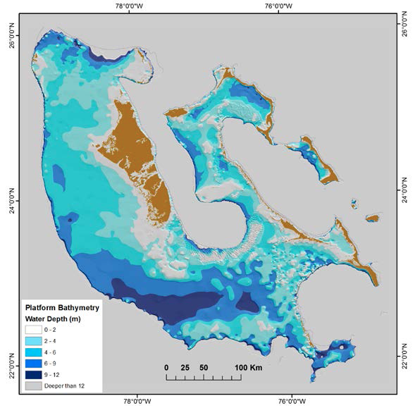
60%, or 61,400 sq. km., of GBB lies in 5m or less of water. This includes areas where accommodation space has been nearly filled by carbonate sand accumulations, e.g., TOTO, Schooners, Exumas, Joulters, and Cat Cay sand complexes, but also includes vast portions of the northern portion of GBB surrounding Andros Island and the New Providence Platform to the west of the Exuma Islands. The 40% of GBB lying in greater than 5m of water occurs mainly in an east-west trending portion of the southern platform. These bathymetric patterns are important as a potential primary control over flooding history, filling (accommodation) history, and the resultant depositional facies patterns. Bathymetric profiles across GBB highlight the irregular filling of accommodation space and graphically emphasize the challenges that occur in correlating depositional cycles of variable thickness across a platform.
GBB also stands behind many of the models used to illustrate depositional facies variation on carbonate platforms, models which have long served as subsurface analogs at a variety of scales. We also used the Landsat TM imagery, the bathymetric digital elevation model, and seafloor sample data compiled into ArcGIS and analyzed with eCognition to develop a depositional facies map that is more robust than previous versions.
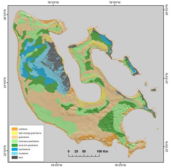
For the portion of the GBB lying west of Andros Island, the facies map was generated by pairing an extensive set of GPS-constrained field observations and samples (n=275; Reijmer et al., 2009) with computer and manual interpretation of the Landsat imagery. For the remainder of the platform, where we lacked such rigorous ground-control, the Landsat imagery was segmented into lithotopes - interpreted to be distinct bodies of uniform sediment - using a combination of edge detection, spectral and textural analysis, and manual editing. A map was then developed by assigning lithotopes to facies classes on the basis of lessons derived from the portion of the platform for which we had rigorous conditioning.
Of particular importance is the detailed and generalized distributions of muddier lithologies and grainier lithologies shown by our mapping relative to that of previous maps. GBB is essentially a very grainy platform with muddier accumulations only in the lee of substantial island barriers; in this regard Andros Island, which is the largest island on GBB, exerts a direct control over the muddiest portion of GBB. Mudstones, wackestones, and mud-rich packstones cover 8%, 5%, and 14%, respectively, of the GBB platform top. By contrast, mud-poor packstones, grainstones, and rudstones account for 20%, 45%, and 3%, respectively. Of the 45% of the platform-top classified as grainstone, only 3% is composed of “high-energy” deposits characterized by the development of sandbar complexes. The most abrupt lateral facies changes are observed leeward of islands, areas which also hold the highest diversity in facies type. There is a clear trend that the widest portion of the platform, which lies to the south of the TOTO and lacks islands, hosts the most continuous expanses of grainstone. The prevalence of rudstone increases from north to south in step with an increase in water depth.